Indian River Systems and Drainage Static GK: Complete Notes with Maps, Tributaries, and Memory Tricks for All Exams
This article covers every major Indian river system and drainage pattern that government exam aspirants need to know — from the Himalayan rivers like Indus, Ganga, and Brahmaputra to peninsular rivers like Godavari, Krishna, Narmada, and Kaveri. It includes complete tables of origins, lengths, tributaries, dams, and exam-favourite one-liners, along with mnemonics and PYQ patterns for SSC, UPSC, IBPS, RRB, Defence, Insurance, and State PCS exams.
Jump to section
- Introduction to Indian River Systems and Drainage
- Core Concepts: Drainage, Drainage System, and Drainage Pattern
- Classification of Indian Rivers
- Major Indian River Systems — Length Table
- Himalayan River Systems in Detail
- Peninsular River Systems in Detail
- Drainage Patterns of India
- Important Nicknames and Sobriquets of Indian Rivers
- Major Dams on Indian Rivers
- Memory Tricks and Mnemonics
- Additional Notes
- One-Liners for Quick Revision
Introduction to Indian River Systems and Drainage
India has one of the largest and most diverse river networks in the world. Rivers are the lifeline of Indian agriculture, industry, transport, power generation, and culture — which is exactly why almost every major Indian city stands on the bank of a river. For government exam aspirants, Indian River Systems and Drainage is one of the highest-yield Static GK chapters, with at least 2 to 4 direct questions every year in SSC, IBPS, RRB, UPSC Prelims, and Defence exams.
Questions are usually factual and one-liner based — origin of a river, left bank vs right bank tributary, name of a river in Tibet, sorrow of which state, longest tributary, drainage pattern, and so on. Once learnt properly, these facts almost never change, which makes this topic a guaranteed scoring chapter for any aspirant preparing for government job notifications.
This complete guide covers every Himalayan and Peninsular river system, every important tributary, all six drainage patterns, the Indus Water Treaty, major dams, and the nicknames repeatedly tested in exams.
Core Concepts: Drainage, Drainage System, and Drainage Pattern
Before learning rivers individually, three foundational terms must be clear because they often appear as one-mark definition questions in SSC and State PCS papers.
- Drainage: The flow of water through well-defined channels is known as drainage.
- Drainage System: The network of such channels (a main river along with its tributaries, distributaries, and basin) is called a drainage system.
- Drainage Pattern: The geometric arrangement of streams in a region, which depends on the slope of land, geological structure, rock type, volume of water, and velocity of water.
- Drainage Basin: The total area drained by a river and its tributaries.
- Watershed: The boundary line that separates one drainage basin from another.
Indian rivers originate from three primary watersheds — the Himalaya and Karakoram range, the Chota Nagpur plateau along with the Vindhya and Satpura ranges, and the Western Ghats. Most Indian rivers drain into the Bay of Bengal, while a few flow westward into the Arabian Sea. The northern Aravalli, parts of Ladakh, and the Thar Desert have inland drainage where rivers do not reach any sea.
Classification of Indian Rivers
Indian rivers are broadly classified into two great families based on their origin and flow behaviour.
Himalayan Rivers vs Peninsular Rivers
| Feature | Himalayan Rivers | Peninsular Rivers |
|---|---|---|
| Nature | Perennial — flow throughout the year, fed by snowmelt and rainfall. | Mostly seasonal — depend mainly on monsoon rainfall. |
| Origin | Originate from Himalayan glaciers (Gangotri, Yamunotri, Mansarovar, Chemayungdung). | Originate from Western Ghats, Satpura, Vindhya, and Chota Nagpur plateau. |
| Age | Younger drainage system, still in youthful stage. | Older drainage system, with fixed and mature courses. |
| Course | Long courses with meanders, oxbow lakes, V-shaped valleys, rapids, waterfalls in upper reaches, and large deltas at mouth. | Fixed course, absence of meanders, shorter and shallower valleys, smaller basins. |
| Silt | Carry heavy silt and form large fertile plains. | Carry less silt, drainage basins are comparatively smaller. |
| Mouth | Form deltas — Sundarbans is the world's largest. | East-flowing peninsular rivers form deltas; west-flowing ones form estuaries. |
| Examples | Indus, Ganga, Brahmaputra and their tributaries. | Godavari, Krishna, Kaveri, Mahanadi, Narmada, Tapi. |
Major Indian River Systems — Length Table
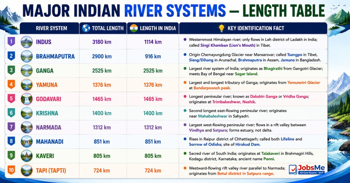
This is the master table every aspirant should memorise — total length and length within India for each major river system.
| River System | Total Length | Length in India | Key Identification Fact |
|---|---|---|---|
| Indus | 3180 km | 1114 km | Westernmost Himalayan river; only flows in Leh district of Ladakh in India; called Singi Khamban (Lion's Mouth) in Tibet. |
| Brahmaputra | 2900 km | 916 km | Origin Chemayungdung Glacier near Mansarovar; called Tsangpo in Tibet, Siang/Dihang in Arunachal, Brahmaputra in Assam, Jamuna in Bangladesh. |
| Ganga | 2525 km | 2525 km | Largest river system of India; originates as Bhagirathi from Gangotri Glacier; meets Bay of Bengal near Sagar Island. |
| Yamuna | 1376 km | 1376 km | Largest and longest tributary of Ganga; originates from Yamunotri Glacier at Bandarpoonch peak. |
| Godavari | 1465 km | 1465 km | Longest peninsular river; known as Dakshin Ganga or Vridha Ganga; originates at Trimbakeshwar, Nashik. |
| Krishna | 1400 km | 1400 km | Second longest east-flowing peninsular river; originates near Mahabaleshwar in Sahyadri. |
| Narmada | 1312 km | 1312 km | Largest west-flowing peninsular river; flows in a rift valley between Vindhya and Satpura; forms estuary, not delta. |
| Mahanadi | 851 km | 851 km | Rises in Raipur district of Chhattisgarh; called both Lifeline and Sorrow of Odisha; site of Hirakud Dam. |
| Kaveri | 805 km | 805 km | Sacred river of South India; originates at Talakaveri in Brahmagiri Hills, Kodagu district, Karnataka; ancient name Ponni. |
| Tapi (Tapti) | 724 km | 724 km | Westward-flowing rift valley river parallel to Narmada; originates from Betul district in Satpura range. |
Himalayan River Systems in Detail
Indus River System
| Attribute | Detail |
|---|---|
| Origin | Glacier near Bokhar Chu in the Kailash Mountain range near Lake Mansarovar, Tibet. |
| Name in Tibet | Singi Khamban (Lion's Mouth); also called Sindhu. |
| Entry into India | Through Jammu and Kashmir, forming a picturesque gorge; flows only through Leh district of Ladakh in India. |
| Tributaries in Kashmir region | Zaskar, Shyok, Nubra, Hunza. |
| Major Indian tributaries | Jhelum, Chenab (largest tributary of Indus), Ravi, Beas, Sutlej. |
| Special feature | Crosses the Himalayas through a 5181 m deep gorge near Attock, north of Nanga Parbat; flows between Ladakh Range and Zaskar Range at Leh. |
| Mouth | Falls into Arabian Sea near Karachi (Pakistan). |
| Treaty | Indus Water Treaty, 1960 — signed between India and Pakistan with the World Bank as mediator. Pakistan controls about 80% of water from western rivers (Indus, Jhelum, Chenab) and India controls about 20% from eastern rivers (Ravi, Beas, Sutlej). |
Ganga River System
| Attribute | Detail |
|---|---|
| Origin | Rises as Bhagirathi from Gangotri Glacier near Gaumukh (3,900 m) in Uttarakhand. |
| Formation of Ganga | At Devprayag, Bhagirathi meets Alaknanda — hereafter the river is called Ganga. |
| Entry into plains | Ganga enters the Northern Plains at Haridwar. |
| States covered | Uttarakhand, Uttar Pradesh, Bihar, Jharkhand, West Bengal — passes through the maximum number of states. |
| Left bank tributaries | Ramganga, Gomati, Ghaghara, Gandak, Kosi, Mahananda. |
| Right bank tributaries | Yamuna, Son, Damodar. |
| Largest tributary | Yamuna — the westernmost and longest tributary, originating from Yamunotri Glacier. |
| Major distributary | Hooghly (in West Bengal). |
| Mouth | Bay of Bengal near Sagar Island; forms the world's largest delta — the Sundarbans (jointly with Brahmaputra). |
Panch Prayag — Five Sacred Confluences of Uttarakhand
| Prayag | Confluence |
|---|---|
| Vishnuprayag | Alaknanda meets Dhauli Ganga. |
| Nandprayag | Alaknanda meets Nandakini. |
| Karnaprayag | Alaknanda meets Pindar. |
| Rudraprayag | Alaknanda meets Mandakini. |
| Devprayag | Alaknanda meets Bhagirathi — Ganga is born here. |
Triveni Sangam at Prayagraj is the sacred confluence of three rivers — Ganga, Yamuna, and the mythical Saraswati.
Brahmaputra River System
| Attribute | Detail |
|---|---|
| Origin | Chemayungdung Glacier in the Kailash range near Mansarovar Lake (Tibet). Same source region as the Indus and Sutlej. |
| Name in Tibet | Tsangpo — meaning "the purifier"; carries less water and silt in Tibet. |
| U-Turn point | Takes a U-turn around Namcha Barwa peak before entering India. |
| Entry into India | Enters India west of Sadiya town in Arunachal Pradesh, where it is called Siang or Dihang. |
| Name in Assam | Brahmaputra — has a braided channel throughout most of its length in Assam. |
| Name in Bangladesh | Jamuna — merges with Padma in Bangladesh and falls into Bay of Bengal. |
| Left bank tributaries | Dibang (Sikang), Lohit, Burhi Dihing, Dhansari. |
| Right bank tributaries | Subansiri, Kameng, Manas, Sankosh, Tista. |
| Important islands | Majuli (largest river island in the world) and Umananda, both in Assam. |
| Special note | Heavy rainfall in India causes huge volume and silt — frequent flooding in Assam and Bangladesh. |
For continuous static GK revision aligned with the latest exam patterns, aspirants can practise topic-wise quizzes on Static GK regularly.
Peninsular River Systems in Detail
East-Flowing Peninsular Rivers (Bay of Bengal)
| River | Origin | States Covered | Key Tributaries | Special Features |
|---|---|---|---|---|
| Mahanadi | Raipur district, Chhattisgarh (Satpura Range). | Maharashtra, Chhattisgarh, Jharkhand, Odisha. | Seonath, Hasdeo, Mand, Ib, Jonking, Tel. | Site of Hirakud Dam (largest dam on the river). Known as Lifeline of Odisha and also Sorrow of Odisha. City of Cuttack stands on its bank. |
| Godavari | Trimbakeshwar near Nashik, Maharashtra. | Maharashtra, Madhya Pradesh, Telangana, Chhattisgarh, Odisha, Andhra Pradesh. | Pranahita (Penganga + Wardha), Indravati, Manjira (right bank), Sabari, Bindusara. | Second longest river in India and longest peninsular river; called Dakshin Ganga/Vridha Ganga. Forms fertile delta at Rajahmundry. Asia's largest rail-cum-road bridge connects Kovvur and Rajahmundry over it. |
| Krishna | Mahabaleshwar in Sahyadri (Western Ghats), Maharashtra. | Maharashtra, Karnataka, Telangana, Andhra Pradesh. | Tungabhadra (formed by Tunga + Bhadra), Bhima, Koyna, Ghataprabha, Malaprabha, Musi, Dudhganga, Yerla. | Second largest east-flowing peninsular river. Hyderabad stands on its tributary Musi. Forms joint Krishna-Godavari delta in Andhra Pradesh. |
| Kaveri | Talakaveri in Brahmagiri Hills, Kodagu district, Karnataka. | Karnataka, Tamil Nadu. | Arkavathy, Hemavati, Kabini, Bhavani, Amaravati, Noyyal, Shimsha, Lakshmana Tirtha. | Sacred river of South India; ancient name Ponni. Considered a perennial river due to North-East Monsoon contribution. Major dams — KRS, Kabini, Harangi, Hemavathi, Mettur. |
West-Flowing Peninsular Rivers (Arabian Sea)
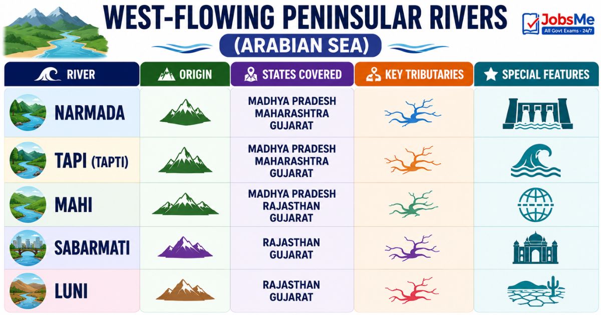
| River | Origin | States Covered | Key Tributaries | Special Features |
|---|---|---|---|---|
| Narmada | Maikala range near Amarkantak, Madhya Pradesh. | Madhya Pradesh, Maharashtra, Gujarat. | Hiran, Orsang, Barna, Kolar. | Largest west-flowing river; flows through a rift valley between Vindhya (north) and Satpura (south). Marks traditional boundary between North and South India. Falls into Gulf of Khambhat — forms estuary, not delta. Sardar Sarovar Project is built on it. |
| Tapi (Tapti) | Betul district, Madhya Pradesh (Satpura range). | Madhya Pradesh, Maharashtra, Gujarat. | Waghur, Aner, Girna, Purna, Panzara, Bori. | Flows in a rift valley parallel to Narmada but is shorter. Drains into Gulf of Cambay (Arabian Sea). Forms estuary like Narmada. |
| Mahi | Vindhya Range, Madhya Pradesh. | Madhya Pradesh, Rajasthan, Gujarat. | Som, Anas, Panam. | One of the three peninsular rivers (Narmada, Tapi, Mahi) flowing east-to-west; crosses Tropic of Cancer twice. |
| Sabarmati | Aravalli range, Rajasthan. | Rajasthan, Gujarat. | Wakal, Hathmati, Sei. | Ahmedabad stands on its bank; rift valley river that drains into Gulf of Khambhat. |
| Luni | Aravalli range (near Pushkar), Rajasthan. | Rajasthan, Gujarat. | Sukri, Mithri, Jawai. | Salty in the lower part; ends in the Rann of Kutch — an example of inland drainage. |
Drainage Patterns of India
Drainage patterns refer to the geometrical shape formed by a river and its tributaries on the land surface. Six patterns are repeatedly tested in exams.
| Pattern | How it Looks | Where it Forms | Indian Example |
|---|---|---|---|
| Dendritic | Branching like tree roots; tributaries join the main river at acute angles (less than 90°). | Where the underlying rock is uniform and can be eroded equally in all directions. | Rivers of the northern plains — Indus, Ganga, Brahmaputra. |
| Parallel | Streams run parallel to each other. | Regions with parallel elongated landforms and a pronounced slope. | Rivers originating in the Western Ghats — Godavari, Krishna, Kaveri, Tungabhadra. |
| Trellis | Primary tributaries flow parallel; secondary tributaries join them at right angles. | Folded topography where hard and soft rocks lie parallel; synclines form the valleys. | Rivers in the upper Himalayan region — Indus, Ganga, Brahmaputra in their upper courses. |
| Rectangular | Tributary streams make sharp bends and meet the main stream at high (nearly 90°) angles. | Regions of strongly jointed rocks and faulted terrain. | Streams of the Vindhyan range — Chambal, Betwa, Ken. |
| Radial | Rivers radiate outward in all directions from a central elevated point. | Conical features like volcanic cones or domes. | Rivers from the Amarkantak plateau — Narmada, Son, Mahanadi. |
| Centripetal | Streams flow inward toward a central depression — opposite of radial. | Basins with closed depressions, sometimes forming ephemeral lakes or salt flats. | Loktak Lake in Manipur. |
Important Nicknames and Sobriquets of Indian Rivers
| Nickname | River | Reason |
|---|---|---|
| Sorrow of Bihar | Kosi | Frequently changes its course and causes devastating floods. |
| Sorrow of Bengal | Damodar | Historically caused destructive floods in West Bengal before dam construction. |
| Sorrow of Odisha / Lifeline of Odisha | Mahanadi | Brought repeated floods to Odisha; now controlled by Hirakud Dam. |
| Dakshin Ganga / Vridha Ganga | Godavari | Largest peninsular river; revered as the Ganga of South India. |
| Ponni | Kaveri | Ancient Tamil name; sacred river of the south. |
| Tsangpo / The Purifier | Brahmaputra | Name used for the river in Tibet. |
| Singi Khamban / Lion's Mouth | Indus | Name used for Indus in Tibet. |
| Jamuna | Brahmaputra in Bangladesh | Should not be confused with the Yamuna of India. |
Major Dams on Indian Rivers
| Dam | River | State | Importance |
|---|---|---|---|
| Bhakra Nangal | Sutlej | Himachal Pradesh / Punjab border | One of the tallest gravity dams in India; multi-purpose project. |
| Tehri Dam | Bhagirathi | Uttarakhand | Tallest dam in India; hydroelectric and irrigation use. |
| Sardar Sarovar | Narmada | Gujarat | One of the largest concrete dams; benefits four states. |
| Indira Sagar | Narmada | Madhya Pradesh | Largest reservoir in India by volume. |
| Hirakud Dam | Mahanadi | Odisha | Longest earthen dam in the world; built to control Mahanadi floods. |
| Nagarjuna Sagar | Krishna | Telangana / Andhra Pradesh | One of the world's largest masonry dams. |
| Mettur Dam | Kaveri | Tamil Nadu | Creates Stanley Reservoir; critical for Tamil Nadu agriculture. |
| Krishna Raja Sagara (KRS) | Kaveri | Karnataka | Famous for Brindavan Gardens. |
| Tungabhadra Dam | Tungabhadra | Karnataka | Major tributary dam of Krishna system. |
Memory Tricks and Mnemonics
Trick 1: Indus Tributaries — "Jhelum Chenab Ravi Beas Sutlej"
Use the acronym "Just Come Right Back Soon" for the five main Indian tributaries of the Indus — Jhelum, Chenab, Ravi, Beas, Sutlej. Remember: the largest tributary of the Indus is the Chenab (C — "Centre, Comes first in size").
Trick 2: Indus Water Treaty — Eastern vs Western Rivers
Remember the rule of "East to Us, West to Them": India gets the Eastern rivers (Ravi, Beas, Sutlej) and Pakistan gets the Western rivers (Indus, Jhelum, Chenab). Use R-B-S for India and I-J-C for Pakistan.
Trick 3: Panch Prayag — "VNKRD"
Going downstream order: Vishnuprayag → Nandprayag → Karnaprayag → Rudraprayag → Devprayag. Story aid: "Vishnu's Naughty Karna Rules Devbhoomi". Devprayag is last because that is where Ganga is born.
Trick 4: West-Flowing Peninsular Rivers — "NTM-SL"
Only five peninsular rivers flow west — "NTM-SL": Narmada, Tapi, Mahi, Sabarmati, Luni. Phrase aid: "No Trip Manages Sabarmati Luni". Of these, only Luni ends in inland drainage at Rann of Kutch.
Trick 5: Brahmaputra's Name Journey — "TSDBJ"
The Brahmaputra changes name as it travels — "Tibet Sleeps, Dihang Brews, Jamuna Joins": Tsangpo (Tibet) → Siang/Dihang (Arunachal Pradesh) → Brahmaputra (Assam) → Jamuna (Bangladesh).
Trick 6: Sorrows of States — "K, D, M"
For the famous "Sorrow of…" questions, remember "KDM — Kosi-Damodar-Mahanadi": Kosi is Sorrow of Bihar, Damodar is Sorrow of Bengal, Mahanadi is Sorrow of Odisha. Alphabet order = Bihar to Bengal to Odisha — easy to recall.
Trick 7: Drainage Patterns — "Dr. PT RRC"
Six patterns in one phrase: "Doctor PT, Run Run, Centripetal" — Dendritic, Parallel, Trellis, Rectangular, Radial, Centripetal. Visual link: Dendritic looks like tree (D for "deru" — tree), Radial looks like sun's rays (R for "radiating"), Centripetal is reverse of Radial.
Trick 8: Godavari is Dakshin Ganga — "Big G of South"
Godavari is the longest peninsular river, originates at Trimbakeshwar in Maharashtra, and is called Dakshin Ganga / Vridha Ganga. Memory link: "Go Daksh, Go Vridh" — both nicknames begin with the same syllables.
Additional Notes
Frequently Confused Facts
- Yamuna vs Jamuna: Yamuna is a tributary of Ganga in India; Jamuna is the name of Brahmaputra in Bangladesh.
- Amaravati city vs Amaravati river: Amaravati city (capital region of Andhra Pradesh) stands on the Krishna River, but the Amaravati river is a tributary of the Kaveri.
- Origin of Indus vs Brahmaputra vs Sutlej: All three rise from the same region near Lake Mansarovar in Tibet — Indus from near Kailash, Brahmaputra from Chemayungdung Glacier.
- Ganga's headstreams: Bhagirathi rises from Gangotri (Gaumukh), Alaknanda has multiple sources; they meet at Devprayag, not at Haridwar or Rishikesh.
- Longest vs Largest: Ganga is the largest river system of India by drainage area; Godavari is the longest peninsular river; Indus is the longest by total length including Pakistan portion.
- Tons vs Tons: Tons is the largest tributary of Yamuna; do not confuse with Tonse or Ton in other systems.
- Narmada and Tapi: Both flow westward in rift valleys, but Narmada flows between Vindhya and Satpura while Tapi flows south of Satpura.
- Sorrow rivers: Kosi (Bihar), Damodar (Bengal), Mahanadi (Odisha) — do not mix up.
Repeating PYQ Patterns
- SSC CGL / SSC GD / SSC CHSL: Origin and tributary questions on Indus and Ganga; "Sorrow of…" type questions; left bank vs right bank tributary identification.
- IBPS PO / Clerk / RRB: Banking Awareness sections often ask which river the city/branch is on (e.g. Hyderabad on Musi, Cuttack on Mahanadi).
- UPSC Prelims: Drainage pattern questions and basin-related ecology questions (e.g. Brahmaputra braided channel, Sundarbans delta).
- Railways NTPC / Group D: Length of rivers, names in different countries (Tsangpo, Singi Khamban, Jamuna).
- Defence (NDA, CDS): Dams and projects — Bhakra Nangal, Sardar Sarovar, Hirakud, Tehri.
- Insurance / LIC AAO: Indus Water Treaty 1960, river-related international agreements.
Quick Insight: Why This Topic Matters in Current Affairs
Indian rivers regularly feature in news — the Cauvery water dispute between Karnataka and Tamil Nadu, the Krishna water tribunal between Telangana and Andhra Pradesh, the Sutlej-Yamuna Link canal between Punjab and Haryana, the Indus Water Treaty discussions between India and Pakistan, and the Brahmaputra dam projects in China. Almost every exam now combines static GK with a current affairs angle, so it pays to track these stories on the Daily Current Affairs page and revise the underlying static facts side-by-side. Even Banking Awareness sections occasionally test which RBI office or PSU bank headquarters is located on which river city.
One-Liners for Quick Revision
- Drainage → flow of water through well-defined channels → network of such channels is the drainage system.
- Three primary watersheds of India → Himalaya-Karakoram, Chota Nagpur with Vindhya-Satpura, and Western Ghats.
- Inland drainage → Northern Aravalli, parts of Ladakh, and Thar Desert → rivers do not reach the sea.
- Himalayan rivers → perennial → fed by glaciers and rainfall → form deltas → examples Indus, Ganga, Brahmaputra.
- Peninsular rivers → seasonal → monsoon-fed → older drainage system → fixed course, no meanders.
- Indus River → 3180 km total, 1114 km in India → origin near Bokhar Chu, Kailash range, Tibet → Singi Khamban in Tibet.
- Indus tributaries (India) → Jhelum, Chenab, Ravi, Beas, Sutlej → Chenab is the largest tributary.
- Indus Water Treaty → signed 1960 → mediator World Bank → India 20% (Ravi, Beas, Sutlej) → Pakistan 80% (Indus, Jhelum, Chenab).
- Indus in India → flows only through Leh district of Ladakh.
- Indus mouth → Arabian Sea near Karachi → crosses Himalayas via 5181 m gorge near Attock.
- Ganga River → 2525 km → origin as Bhagirathi from Gangotri Glacier near Gaumukh, Uttarakhand.
- Ganga's birth → at Devprayag where Bhagirathi meets Alaknanda.
- Ganga enters plains → at Haridwar → flows through UK, UP, Bihar, Jharkhand, West Bengal.
- Ganga's largest tributary → Yamuna → westernmost and longest → origin Yamunotri Glacier at Bandarpoonch.
- Ganga left bank tributaries → Ramganga, Gomati, Ghaghara, Gandak, Kosi, Mahananda.
- Ganga right bank tributaries → Son, Yamuna, Damodar.
- Ganga's distributary → Hooghly (in West Bengal).
- Ganga mouth → Bay of Bengal near Sagar Island → forms Sundarbans Delta (world's largest, shared with Brahmaputra).
- Panch Prayag order → Vishnuprayag → Nandprayag → Karnaprayag → Rudraprayag → Devprayag.
- Triveni Sangam → at Prayagraj → confluence of Ganga, Yamuna, Saraswati.
- Yamuna largest tributary → Tons.
- Yamuna other tributaries → Sin, Hindon, Betwa, Ken, Chambal.
- Brahmaputra → 2900 km total, 916 km in India → origin Chemayungdung Glacier near Mansarovar.
- Brahmaputra names → Tsangpo (Tibet) → Siang/Dihang (Arunachal) → Brahmaputra (Assam) → Jamuna (Bangladesh).
- U-turn point of Brahmaputra → Namcha Barwa peak.
- Brahmaputra left bank tributaries → Dibang, Lohit, Burhi Dihing, Dhansari.
- Brahmaputra right bank tributaries → Subansiri, Kameng, Manas, Sankosh, Tista.
- Brahmaputra islands → Majuli (world's largest river island), Umananda (both in Assam).
- Brahmaputra special feature → braided channel through Assam → frequent floods in Assam and Bangladesh.
- Godavari → 1465 km → origin Trimbakeshwar, Nashik, Maharashtra → longest peninsular river → Dakshin Ganga.
- Godavari tributaries → Pranahita, Indravati, Manjira (right bank), Sabari, Bindusara.
- Godavari delta → Rajahmundry → Bay of Bengal → Asia's largest rail-cum-road bridge at Kovvur-Rajahmundry.
- Krishna → 1400 km → origin near Mahabaleshwar in Sahyadri → second longest east-flowing peninsular river.
- Krishna tributaries → Tungabhadra (formed by Tunga + Bhadra), Bhima, Koyna, Musi, Ghataprabha, Malaprabha.
- Krishna delta → joint Krishna-Godavari delta in Andhra Pradesh.
- Hyderabad → stands on Musi River → tributary of Krishna.
- Kaveri → 805 km → origin Talakaveri, Brahmagiri Hills, Kodagu district, Karnataka → ancient name Ponni.
- Kaveri tributaries → Arkavathy, Hemavati, Kabini, Bhavani, Amaravati, Noyyal, Shimsha.
- Kaveri major dams → KRS, Kabini, Harangi, Hemavathi, Mettur.
- Kaveri perennial nature → due to North-East Monsoon contribution.
- Mahanadi → 851 km → origin Raipur district, Chhattisgarh → Lifeline of Odisha / Sorrow of Odisha.
- Mahanadi tributaries → Seonath, Hasdeo, Mand, Ib, Jonking, Tel.
- Mahanadi key dam → Hirakud (longest earthen dam in the world).
- Cuttack → on Mahanadi.
- Narmada → 1312 km → origin Amarkantak (Maikala range), Madhya Pradesh → largest west-flowing peninsular river.
- Narmada rift valley → between Vindhya (north) and Satpura (south).
- Narmada mouth → Arabian Sea via Gulf of Khambhat → forms estuary (Bharuch district) not a delta.
- Narmada project → Sardar Sarovar Project.
- Narmada tributaries → Hiran, Orsang, Barna, Kolar.
- Tapi (Tapti) → 724 km → origin Betul district, MP (Satpura range) → flows in rift valley parallel to Narmada.
- Tapi tributaries → Waghur, Aner, Girna, Purna, Panzara, Bori.
- Tapi mouth → Gulf of Cambay (Arabian Sea).
- Three east-to-west peninsular rivers → Narmada, Tapi, Mahi.
- Five west-flowing peninsular rivers → Narmada, Tapi, Mahi, Sabarmati, Luni.
- Luni → ends in Rann of Kutch → example of inland drainage.
- Sabarmati → drains into Gulf of Khambhat → Ahmedabad on its banks.
- Sorrow of Bihar → Kosi River → frequently changes course.
- Sorrow of Bengal → Damodar River → controlled by Damodar Valley Corporation.
- Sorrow of Odisha → Mahanadi → tamed by Hirakud Dam.
- Dakshin Ganga / Vridha Ganga → Godavari.
- Dendritic pattern → tree-root shape → northern plains rivers (Indus, Ganga, Brahmaputra).
- Parallel pattern → Western Ghats rivers (Godavari, Krishna, Kaveri, Tungabhadra).
- Trellis pattern → folded topography → upper Himalayan courses of Indus, Ganga, Brahmaputra.
- Rectangular pattern → faulted, jointed rocks → Vindhyan streams Chambal, Betwa, Ken.
- Radial pattern → conical features → Amarkantak rivers Narmada, Son, Mahanadi.
- Centripetal pattern → streams flow inward → Loktak Lake, Manipur.
- Folding → bend in crust → upward = anticline, downward = syncline → causes mountains.
- Faulting → breaks in crust → causes earthquakes.
- Bhakra Nangal → Sutlej → Himachal-Punjab.
- Tehri Dam → Bhagirathi → Uttarakhand → tallest in India.
- Sardar Sarovar → Narmada → Gujarat.
- Indira Sagar → Narmada → Madhya Pradesh → largest reservoir in India.
- Nagarjuna Sagar → Krishna → Telangana/AP.
- Mettur Dam → Kaveri → Tamil Nadu.
- KRS Dam → Kaveri → Karnataka → Brindavan Gardens.
- Indian sub-continent → has 7 major river systems and more than 400 rivers.
- Glaciers in basins → Indus 3500, Ganga 1000, Brahmaputra 660.
- Left bank rule → tributary joining the left side of the main river as you face downstream.
- Right bank rule → tributary joining the right side of the main river as you face downstream.
For more topic-wise revision material, aspirants can use the curated Static GK notes and test their command of these one-liners with the Daily Current Affairs quiz. Banking and insurance candidates can additionally strengthen their preparation through the Banking Awareness quiz and computer-section practice on Computer Awareness.
Free quiz • No signup required
Put this topic into practice with Indian Cultural Institutions – Static GK MCQ Quiz. It is the quickest way to reinforce what you just learned.
Frequently Asked Questions
Which is the longest river in India?
Which is the longest river of Peninsular India?
Why is the Kosi called the Sorrow of Bihar?
What is the Indus Water Treaty 1960?
Where do the Bhagirathi and Alaknanda meet to form the Ganga?
What are the names of the Brahmaputra in different countries?
Which peninsular rivers flow westward into the Arabian Sea?
Why does the Narmada not form a delta?
What is the difference between Himalayan and Peninsular rivers?
Which drainage pattern is found in the Vindhyan rivers like Chambal, Betwa, and Ken?

About the author