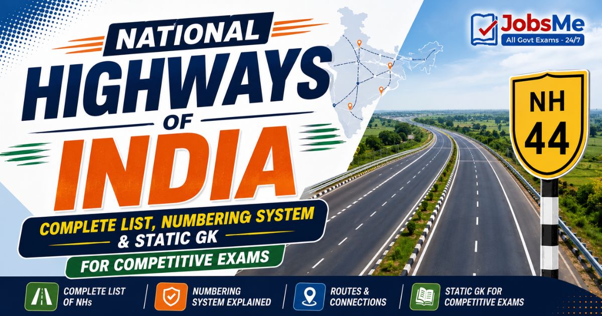
National Highways of India – Complete List, Numbering System & Static GK for Competitive Exams with Memory Tricks
This article gives a complete, exam-ready guide to the National Highways of India, covering the longest highway (NH 44), the shortest highway, the 2010 numbering system, key corridors like the Golden Quadrilateral and the North-South & East-West corridors, the role of NHAI and MoRTH, milestone colour codes, and the top longest highways with their routes. It includes memory tricks, frequently confused facts, repeating PYQ patterns, and one-liners for quick revision. All facts are arranged in a structured format to help UPSC, SSC, IBPS, RRB, PSU, and State PCS aspirants score better in General Awareness and Static GK sections.
Jump to section
Introduction
National Highways form the backbone of India's road transport network, connecting the major cities, ports, state capitals, and border regions across the country. Although National Highways make up only about 2 per cent of India's total road length, they carry more than 40 per cent of all road traffic, making them critically important for trade, defence movement, and economic growth. The longest among them, National Highway 44 (NH 44), runs all the way from Srinagar in the north to Kanyakumari in the south, while the network is planned and maintained by the Ministry of Road Transport and Highways (MoRTH) through the National Highways Authority of India (NHAI).
Questions on National Highways appear regularly in UPSC Prelims, SSC CGL, IBPS PO, RRB NTPC, SBI Clerk, State PCS, and various Insurance and Defence exams. Examiners typically ask which is the longest or shortest highway, how the highways are numbered, what the Golden Quadrilateral connects, which cities a particular highway links, or what the milestone colours indicate. This article brings together every important fact on National Highways in a structured, exam-ready format. To explore more such topics, you can refer to the Static GK section on Jobsme.in.
The topic is also closely linked to current affairs themes such as the Bharatmala Pariyojana, the PM Gati Shakti master plan, the shift to GNSS / GPS-based tolling replacing FASTag lanes, and new expressways like the Delhi-Mumbai Expressway — making it doubly important for aspirants preparing for the Economy and Infrastructure portions of competitive exams.
Core Concepts: Understanding National Highways
National Highways (NHs) are arterial roads declared and funded by the Central Government of India under the National Highways Act, 1956. They connect different states and union territories and ensure smooth inter-state transport. Understanding a few core ideas makes the entire topic easier to remember and answer.
- Ownership: National Highways are owned by the Ministry of Road Transport and Highways (MoRTH). Only the Central Government has the power to notify or de-notify any road as a National Highway.
- Construction and maintenance agencies: NHAI, the National Highways and Infrastructure Development Corporation Limited (NHIDCL), the Central Public Works Department (CPWD), and the Public Works Departments (PWDs) of state governments build and maintain the highways.
- NHAI: Established under the National Highways Authority of India Act, 1988, and became operational in February 1995. It develops, maintains, and manages National Highways and handles toll collection, often through the Public-Private Partnership (PPP) model.
- NHIDCL: Started functioning on 18 July 2014; it focuses on strategic roads in border areas and difficult hilly terrain such as the North-East, Jammu & Kashmir, Ladakh, Himachal Pradesh, and Uttarakhand.
- Highways vs Expressways: National Highways are largely at-grade roads with partial controlled access and are designed for speeds of about 100 km/h, whereas expressways are fully controlled-access roads with entry and exit only through ramps.
- Milestone colour codes: Yellow and white milestones indicate National Highways, green and white indicate State Highways, and black/blue and white indicate city or district roads.
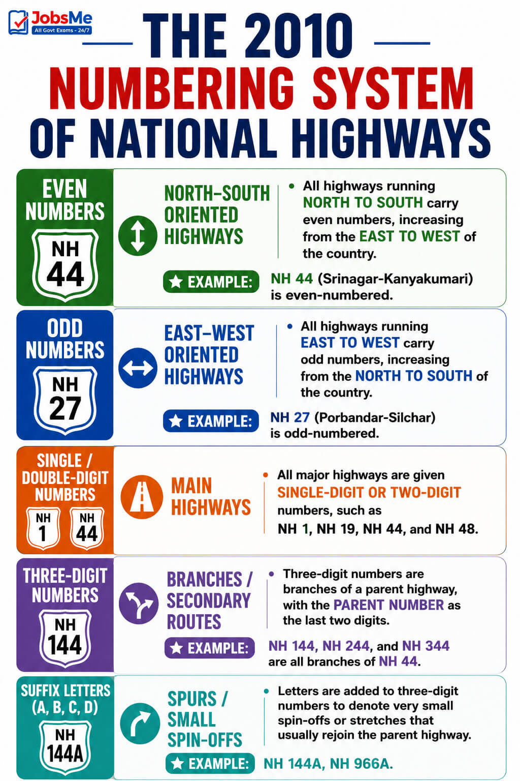
The 2010 Numbering System of National Highways
Until 2010, highways were numbered under the National Highways Act, 1956, in a way that gave no clue about their direction or location. On 28 April 2010, MoRTH notified a rationalised, grid-based numbering system in the Gazette of India. Knowing this system lets you answer most questions logically even without memorising every number. You can practise such reasoning-based questions on the Static GK Quiz on Jobsme.in.
| Rule | Direction / Type | Key Details |
|---|---|---|
| Even numbers | North-South oriented highways | All highways running north to south carry even numbers, increasing from the east to the west of the country. Example: NH 44 (Srinagar-Kanyakumari) is even-numbered. |
| Odd numbers | East-West oriented highways | All highways running east to west carry odd numbers, increasing from the north to the south of the country. Example: NH 27 (Porbandar-Silchar) is odd-numbered. |
| Single / double-digit numbers | Main highways | All major highways are given single-digit or two-digit numbers, such as NH 1, NH 19, NH 44, and NH 48. |
| Three-digit numbers | Branches / secondary routes | Three-digit numbers are branches of a parent highway, with the parent number as the last two digits. Example: NH 144, NH 244, and NH 344 are all branches of NH 44. |
| Suffix letters (A, B, C, D) | Spurs / small spin-offs | Letters are added to three-digit numbers to denote very small spin-offs or stretches that usually rejoin the parent highway. Example: NH 144A, NH 966A. |
Longest and Shortest National Highways in India
Two of the most frequently asked facts in exams are the longest and shortest National Highways. Note the key figures below.
| Record | Highway | Key Details |
|---|---|---|
| Longest National Highway | NH 44 (old NH 7) | Runs from Srinagar (Jammu & Kashmir) to Kanyakumari (Tamil Nadu); commonly quoted as around 3,745 km, with more recent official sources listing it at 4,112 km. It covers the North-South Corridor of the NHDP and passes through about 11-12 states. |
| Formed by merging | NH 44 | Created by merging seven old highways — NH 1A, NH 1, NH 2, NH 3, NH 75, NH 26, and old NH 7 — under the 2010 renumbering scheme. |
| Shortest National Highway | NH 766EE | Spans only about 4.27 km from Hettikeri to Belekeri Port in Karnataka; it is currently the shortest officially listed National Highway. Earlier, NH 118 and NH 548 (around 5 km each) were widely cited as the shortest. |
| Longest under old numbering | Old NH 7 | Before 2010, the longest highway was NH 7 from Varanasi to Kanyakumari, covering about 4,572 km; most of it is now part of NH 44. |
Top Longest National Highways in India
The following table lists the major long-distance National Highways with their routes and the states they connect.
| Highway | Route (Approx.) | Key Details |
|---|---|---|
| NH 44 | Srinagar to Kanyakumari | The longest National Highway in India (around 3,745-4,112 km); the main North-South Corridor passing through states like Jammu & Kashmir, Punjab, Haryana, Delhi, Uttar Pradesh, Madhya Pradesh, Maharashtra, Telangana, Andhra Pradesh, Karnataka, and Tamil Nadu. |
| NH 27 | Porbandar to Silchar | The second-longest National Highway (around 3,500 km); the main East-West Corridor connecting Gujarat in the west to Assam in the east. It hosts the Dhola-Sadiya Bridge over the River Lohit. |
| NH 48 | Delhi to Chennai | One of the busiest commercial routes; passes through Jaipur, Ahmedabad, Vadodara, Mumbai, and Bengaluru, linking the capital with major industrial hubs and port cities. |
| NH 52 | Sangrur (Punjab) to Ankola (Karnataka) | Stretches over 2,300 km; passes through fertile agricultural belts in the north and mineral-rich and coastal areas in the south. |
| NH 30 | Sitarganj (Uttarakhand) to Ibrahimpatnam (Andhra Pradesh) | Runs roughly 2,000 km through the heart of the country; often described as one of the safest highways due to its straightforward connectivity. |
| NH 53 | Hazira (Gujarat) to Paradip / eastern India | About 1,781 km; a major east-west freight corridor across central India. |
| NH 16 | Kolkata to Chennai | About 1,711 km; a key eastern coastal corridor connecting West Bengal, Odisha, Andhra Pradesh, and Tamil Nadu. |
| NH 66 | Panvel (Mumbai region) to Kanyakumari | About 1,622 km; the western coastal highway running along Maharashtra, Goa, Karnataka, and Kerala. |
| NH 19 | Delhi to Kolkata | About 1,435 km; runs along part of the historic Grand Trunk Road and is one of the busiest National Highways, connecting Delhi, Uttar Pradesh, Bihar, Jharkhand, and West Bengal. |
| NH 6 | Jorabat (Meghalaya) to Seling (Mizoram) | About 1,873 km in the northeastern region; strategically important for connecting remote north-eastern areas with the rest of India. |
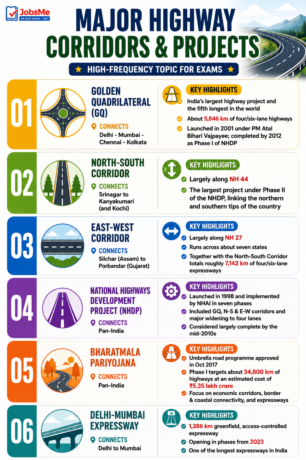
Major Highway Corridors and Projects
India's highway network is organised around a few landmark corridors and umbrella programmes. These are high-frequency exam topics, especially for UPSC Prelims and Economy sections.
| Corridor / Project | Connects | Key Details |
|---|---|---|
| Golden Quadrilateral (GQ) | Delhi - Mumbai - Chennai - Kolkata | India's largest highway project and the fifth longest in the world; about 5,846 km of four/six-lane highways. Launched in 2001 under PM Atal Bihari Vajpayee and completed in stages by 2012 as Phase I of the NHDP. |
| North-South Corridor | Srinagar to Kanyakumari (and Kochi) | Largely along NH 44; the largest project under Phase II of the NHDP, linking the northern and southern tips of the country. |
| East-West Corridor | Silchar (Assam) to Porbandar (Gujarat) | Largely along NH 27; runs across about seven states. Together with the North-South Corridor it totals roughly 7,142 km of four/six-lane expressways. |
| National Highways Development Project (NHDP) | Pan-India | Launched in 1998 and implemented by NHAI in seven phases; included the GQ, the N-S and E-W corridors, and major widening to four lanes. Considered largely complete by the mid-2010s. |
| Bharatmala Pariyojana | Pan-India | Umbrella road programme approved by the Union Cabinet in October 2017; Phase I targets about 34,800 km of highways at an estimated cost of ₹5.35 lakh crore, emphasising economic corridors, border and coastal connectivity, and expressways. |
| Delhi-Mumbai Expressway | Delhi to Mumbai | A 1,386 km greenfield, access-controlled expressway opening in phases from 2023; one of the longest expressways in India. |
Memory Tricks and Mnemonics
Trick 1: Even and Odd Direction Rule — "EVEN goes up-down"
The single most useful trick for this topic:
- EVEN numbers = North-South highways (vertical, "up-down"). Numbers increase from East to West.
- ODD numbers = East-West highways (horizontal). Numbers increase from North to South.
"EVEN stands tall (North-South); ODD lies flat (East-West)."
Trick 2: NH 44 — "Srinagar to Kanyakumari, top to toe"
To remember the longest highway and its end points:
- NH 44 → longest → runs from the very top of India (Srinagar) to the very bottom (Kanyakumari).
- It was earlier the famous NH 7.
"Forty-Four runs from snow to shore."
Trick 3: NH 44's Seven Old Highways — count the merge
NH 44 was formed by merging seven old highways. Group them as:
- The "ones and twos and threes" → NH 1A, NH 1, NH 2, NH 3.
- The "rest" → NH 75, NH 26, and old NH 7.
"Seven roads became one giant NH 44."
Trick 4: Branch Number Logic — "Last two digits give the parent"
For any three-digit highway, the last two digits tell you the parent highway:
- 144, 244, 344 → all branches of NH 44.
- 966A → a small spur with a suffix letter.
"See the last two — find the parent's clue."
Trick 5: Milestone Colours — "Yellow for the Nation"
Use the colour of the milestone top band:
- Yellow + white → National Highway.
- Green + white → State Highway.
- Black / Blue + white → City / district road.
"Yellow = National, Green = State, Black = local."
Trick 6: The Big Two Corridors — "44 stands, 27 lies"
- NH 44 → North-South Corridor (Srinagar-Kanyakumari) — stands vertically.
- NH 27 → East-West Corridor (Porbandar-Silchar) — lies horizontally.
"They cross like an X at Jhansi."
Trick 7: Project Timeline — "GQ then Bharatmala"
Remember the order of big projects:
- NHDP (1998) → Golden Quadrilateral launched 2001, completed 2012.
- Bharatmala (2017) → newer umbrella programme.
"First the Quadrilateral, then the Mala."
Additional Notes
Frequently Confused Facts
- Longest highway length: NH 44's length is quoted as both 3,745 km (older NHAI data) and 4,112 km (recent official sources). Both can appear correct; choose based on the option set given, but the route (Srinagar-Kanyakumari) never changes.
- NH 44 vs NH 7: NH 44 is the new number; NH 7 was the old number. Do not treat them as two different highways.
- Even vs Odd direction: Even = North-South; Odd = East-West. Many wrong notes reverse this, so trust the official 2010 rule.
- Shortest highway: The currently listed shortest is NH 766EE (about 4.27 km) in Karnataka; older references mention NH 118 and NH 548 (around 5 km). Check the year of the question.
- Golden Quadrilateral vs Corridors: GQ connects four metros (Delhi, Mumbai, Chennai, Kolkata); the N-S and E-W Corridors connect the four geographic extremities (Srinagar/Kanyakumari and Porbandar/Silchar).
- NHAI vs NHIDCL: NHAI handles general National Highways; NHIDCL handles strategic and border-area highways in difficult terrain.
- Act years: National Highways Act = 1956; NHAI Act = 1988 (operational 1995). Do not mix the two.
- Bharatmala vs NHDP: NHDP (1998) is the older project; Bharatmala (2017) is the newer umbrella programme that replaced the length-based approach with freight-based corridor planning.
Repeating PYQ Patterns
Certain facts on National Highways are asked repeatedly. NH 44 as the longest highway (Srinagar-Kanyakumari), the even/odd numbering rule, the Golden Quadrilateral connecting the four metros, the role of NHAI and the year 1988/1995, the milestone colour code, and the North-South vs East-West corridor end points appear most often in UPSC Prelims, SSC CGL, and RRB NTPC papers. Banking exams (IBPS PO, SBI Clerk) frequently ask the longest and shortest highway and the full form of NHAI. State PCS exams add region-specific questions — Karnataka PCS on NH 66 and NH 48 stretches, Tamil Nadu PCS on the NH 44 terminus at Kanyakumari, and Gujarat PCS on the East-West Corridor terminus at Porbandar. You can revise more such facts on the Static GK notes and test yourself with the Static GK Quiz on Jobsme.in.
Quick Insight
National Highways stay in the news because of ongoing reforms — the rollout of GNSS / GPS-based tolling to gradually replace traditional FASTag lanes, the creation of EV-friendly "green corridors" with fast-charging stations, and large greenfield expressways under Bharatmala and PM Gati Shakti. The shift from a length-based to a freight-and-corridor-based planning model reflects India's push toward a logistics-driven economy under Vision 2047, which makes this a high-value topic for both the Static GK and current affairs sections of competitive exams.
One-Liners for Quick Revision
- Longest National Highway → NH 44 → Srinagar to Kanyakumari; old NH 7.
- NH 44 length → about 3,745 km (older) / 4,112 km (recent official) → North-South Corridor of NHDP.
- NH 44 formed by merging → NH 1A, NH 1, NH 2, NH 3, NH 75, NH 26, old NH 7 → seven highways.
- Shortest National Highway → NH 766EE → about 4.27 km, Hettikeri to Belekeri Port, Karnataka.
- Earlier shortest highways → NH 118 and NH 548 → about 5 km each.
- Second-longest highway → NH 27 → Porbandar to Silchar; East-West Corridor.
- NH 48 → Delhi to Chennai → one of the busiest commercial routes.
- NH 19 → Delhi to Kolkata → part of the Grand Trunk Road.
- NH 16 → Kolkata to Chennai → eastern coastal corridor.
- NH 66 → western coastal highway → Maharashtra-Goa-Karnataka-Kerala.
- Numbering system adopted → 28 April 2010 → notified by MoRTH in the Gazette of India.
- Even-numbered highways → North-South direction → numbers increase from East to West.
- Odd-numbered highways → East-West direction → numbers increase from North to South.
- Three-digit highways → branches of a parent highway → e.g., 144, 244, 344 branch off NH 44.
- Suffix letters (A, B, C, D) → small spurs of a branch highway → e.g., NH 144A.
- National Highways Act → 1956 → made NHs the central government's responsibility.
- NHAI Act → 1988 → NHAI became operational in February 1995.
- NHIDCL → started 18 July 2014 → strategic and border-area roads in hilly terrain.
- Nodal ministry → Ministry of Road Transport and Highways (MoRTH).
- Milestone colours → Yellow/white = National Highway; Green/white = State Highway; Black-Blue/white = city road.
- Golden Quadrilateral → Delhi-Mumbai-Chennai-Kolkata → about 5,846 km; Phase I of NHDP.
- GQ launched / completed → launched 2001 (Vajpayee) → completed in stages by 2012.
- North-South Corridor → Srinagar to Kanyakumari (and Kochi) → mainly along NH 44.
- East-West Corridor → Silchar to Porbandar → mainly along NH 27.
- NHDP → launched 1998 → implemented by NHAI in seven phases.
- Bharatmala Pariyojana → approved October 2017 → Phase I target about 34,800 km, cost ₹5.35 lakh crore.
- Delhi-Mumbai Expressway → 1,386 km greenfield expressway → phased opening from 2023.
- Highway share of road length → about 2 per cent of total roads → carry over 40 per cent of road traffic.
- Design speed of National Highways → about 100 km/h.
- Highways vs Expressways → NHs are at-grade with partial access; expressways are fully controlled-access.
- NH 44 and NH 27 meeting point → Jhansi, Uttar Pradesh → crossing of the two main corridors.
- Old NH 7 → Varanasi to Kanyakumari → longest under old numbering (about 4,572 km).
For more Static GK topics like Indian dams, ports, and rivers, explore the Static GK section on Jobsme.in. You can also test your preparation with the Daily Current Affairs Quiz and check the latest openings at Latest Government Job Notifications.
Free quiz • No signup required
Put this topic into practice with Indian Cultural Institutions – Static GK MCQ Quiz. It is the quickest way to reinforce what you just learned.
Frequently Asked Questions
Which is the longest National Highway in India?
Which is the shortest National Highway in India?
How are National Highways numbered in India?
Why is NH 44 an even number even though it is very long?
What does the Golden Quadrilateral connect?
What is the difference between NHAI and MoRTH?
What do the colours on highway milestones indicate?
What is the North-South and East-West Corridor?
Which old highways were merged to form NH 44?
What is the Bharatmala Pariyojana?

About the author