Important Himalayan Passes of India – Static GK & General Awareness for Competitive Exams with Memory Tricks
This article presents a complete, state-wise list of the important Himalayan passes of India, covering their location, mountain range, altitude, the regions or countries they connect, and the rivers or trade routes associated with them. It includes high-frequency exam passes like Khardung La, Zoji La, Banihal, Rohtang, Bara-lacha La, Shipki La, Nathu La, Jelep La, Lipulekh, Mana, Sela, and Bomdi La, along with memory tricks and one-liners for quick revision. All facts are arranged in exam-ready format to help UPSC, SSC, IBPS, RRB, PSU, and State PCS aspirants score better in General Awareness and Indian Geography sections.
Jump to section
Introduction
A mountain pass is a natural gap or low point in a mountain range that provides a navigable route across otherwise difficult terrain. In the Himalayan and Karakoram regions, such passes are often called "La", a Tibetan word meaning pass — which is why so many of them end in "La", such as Zoji La, Nathu La, and Khardung La. These passes have served for centuries as vital corridors for trade, pilgrimage, military movement, and cultural exchange between India and its neighbours like China, Nepal, Bhutan, and Myanmar.
Questions on Himalayan passes appear regularly in UPSC Prelims, SSC CGL, IBPS PO, RRB NTPC, SBI Clerk, State PCS, and various Insurance and Defence exams. The typical questions ask which pass lies in which state, which pass connects which two regions or countries, which river enters India through a particular pass, or which is the highest motorable pass. This article brings together every important Himalayan pass in a structured, exam-ready format. To explore other related Static GK topics, you can refer to the Static GK section on Jobsme.in.
Himalayan passes are also closely linked to current affairs themes such as India-China border trade through Nathu La, the construction of the Atal Tunnel and Zoji La Tunnel, the Umling La road becoming the world's highest motorable road, and the Kailash-Mansarovar pilgrimage route via Lipulekh — making this topic doubly important for aspirants preparing for UPSC Mains and the General Studies geography paper as well. For the latest developments, you can follow the Daily Current Affairs updates on Jobsme.in.
Core Concepts: Understanding Himalayan Passes
Before memorising individual passes, it helps to understand a few key ideas that the exams test most often. A pass usually lies near a river source and acts as a drainage divide between two basins, which is why several rivers enter India through famous passes. Many passes are seasonal, closing for up to six months in winter due to heavy snow, while the government increasingly builds tunnels beneath them for all-weather access.
Key Points to Remember
- "La" means pass: In Tibetan and Ladakhi regions, a pass is called "La" — hence Zoji La, Chang La, Bara-lacha La, and Jelep La.
- Ladakh has the most high-altitude passes: The Union Territory of Ladakh holds the largest number of high-altitude Himalayan passes in India.
- Indian Himalayan arc: The Himalayan ranges run through the Union Territories of Jammu & Kashmir and Ladakh and the states of Himachal Pradesh, Uttarakhand, Sikkim, and Arunachal Pradesh.
- Tunnels under passes: The Jawahar Tunnel lies under Banihal Pass, and the Atal Tunnel lies under Rohtang Pass — both provide year-round road access.
- Rivers and passes: The Sutlej (Satluj) river enters India through Shipki La, and the Chandra and Bhaga rivers (headwaters of the Chenab) originate near Bara-lacha La.
- Trade and pilgrimage: Nathu La and Shipki La are official India-China border trade points, while Lipulekh serves Kailash-Mansarovar pilgrims.
Important Himalayan Passes of India - State-wise List
The following tables list the most exam-relevant Himalayan passes grouped by state or Union Territory, along with their range, altitude, the regions they connect, and key facts. Memorise each pass along with its state and connecting regions, as this is exactly how questions are framed.
Passes in Ladakh
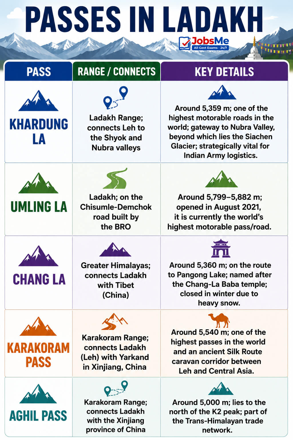
| Pass | Range / Connects | Key Details |
|---|---|---|
| Khardung La | Ladakh Range; connects Leh to the Shyok and Nubra valleys | Around 5,359 m; one of the highest motorable roads in the world and the gateway to Nubra Valley, beyond which lies the Siachen Glacier; strategically vital for Indian Army logistics. |
| Umling La | Ladakh; on the Chisumle-Demchok road built by the BRO | Around 5,799-5,882 m; opened in August 2021, it is currently the world's highest motorable pass/road. |
| Chang La | Greater Himalayas; connects Ladakh with Tibet (China) | Around 5,360 m; on the route to Pangong Lake; named after the Chang-La Baba temple; closed in winter due to heavy snow. |
| Karakoram Pass | Karakoram Range; connects Ladakh (Leh) with Yarkand in Xinjiang, China | Around 5,540 m; one of the highest passes in the world and an ancient Silk Route caravan corridor between Leh and Central Asia. |
| Aghil Pass | Karakoram Range; connects Ladakh with the Xinjiang province of China | Around 5,000 m; lies to the north of the K2 peak; part of the Trans-Himalayan trade network. |
Passes in Jammu & Kashmir
| Pass | Range / Connects | Key Details |
|---|---|---|
| Zoji La | Zaskar (Zanskar) Range; connects Srinagar with Kargil and Leh | Around 3,528-3,850 m; vital pass on the Srinagar-Leh Highway (NH-1D); known as the "Gateway to Ladakh"; maintained by the BRO and closed roughly December to mid-May. The Zoji La Tunnel under construction will give all-weather access to Ladakh. |
| Banihal Pass | Pir Panjal Range; connects Jammu with the Kashmir Valley | Around 2,832 m; "Banihal" means blizzard in Kashmiri; the Jawahar Tunnel was built beneath it for round-the-year road access between Jammu and Srinagar. |
| Pir Panjal Pass (Peer Ki Gali) | Pir Panjal Range; connects Srinagar with Rajouri and Poonch via the Mughal Road | A traditional Mughal-era pass mentioned in Kalhana's Rajatarangini; it offered the shortest route from Jammu to the Kashmir Valley before Partition closed parts of it. |
| Burzil Pass | Connects the Astore Valley of Kashmir with the Deosai Plains, towards Gilgit | Around 4,100 m; the Astore River originates near this pass; snowbound for much of the year. |
Passes in Himachal Pradesh
| Pass | Range / Connects | Key Details |
|---|---|---|
| Rohtang Pass | Eastern Pir Panjal Range; connects the Kullu Valley (Manali) with Lahaul and Spiti | Around 3,978 m; about 51 km from Manali; the Atal Tunnel (about 9.02 km) lies below it and is the world's longest highway tunnel above 10,000 feet; a major tourism and transport route, frequently closed by heavy snow. |
| Bara-lacha La | Zaskar (Zanskar) Range; connects Lahaul (Himachal Pradesh) with Leh (Ladakh) on the Leh-Manali Highway | Around 4,883-4,890 m; the Chandra and Bhaga rivers — the headwaters of the Chenab — originate near it; remains snow-covered for around six months. |
| Shipki La | Kinnaur district; connects Himachal Pradesh with Tibet (China) | Around 4,300-4,500 m; the river Sutlej (Satluj) enters India through this pass; an important India-China border trade point near the village of Khab. |
| Debsa Pass | Greater Himalayas; connects the Kullu and Spiti districts | Around 5,270 m; a high trekking route between Kullu and the Spiti Valley. |
Passes in Uttarakhand
| Pass | Range / Connects | Key Details |
|---|---|---|
| Lipulekh Pass | Connects Uttarakhand (Byans Valley, Pithoragarh) with Tibet (China) | A historic route for Kailash-Mansarovar pilgrims; an important India-China trade and pilgrimage corridor in the Kumaon Himalayas. |
| Mana Pass | Greater Himalayas; connects Uttarakhand with Tibet (China) | Around 5,611 m; situated north of Badrinath within the Nanda Devi Biosphere Reserve; one of the highest vehicle-accessible passes in the world; snow-covered for around six months. |
| Niti Pass | Connects Uttarakhand with Tibet (China), en route to Kailash-Mansarovar | Around 5,068 m (often cited near 5,800 m at the higher approaches); inaccessible for about six months due to heavy snow. |
| Kalindi Pass | Garhwal Himalayas of the Greater Himalayas | A high glaciated pass near the Indo-Tibet border; its meltwater feeds towards the Gangotri glacier region. |
Passes in Sikkim
| Pass | Range / Connects | Key Details |
|---|---|---|
| Nathu La | Connects Sikkim with the Tibet Autonomous Region of China | Around 4,310 m; an ancient Silk Route point that historically linked Darjeeling and the Chumbi Valley to Tibet; closed after the 1962 war and reopened for bilateral border trade in 2006; controlled by the Indian Army. |
| Jelep La | Chumbi Valley; connects Sikkim with Tibet (China) | Around 4,270 m; meaning "the lovely level pass"; shaped by the Teesta (Tista) River; a relatively easier trade route between India and Tibet. |
Passes in Arunachal Pradesh
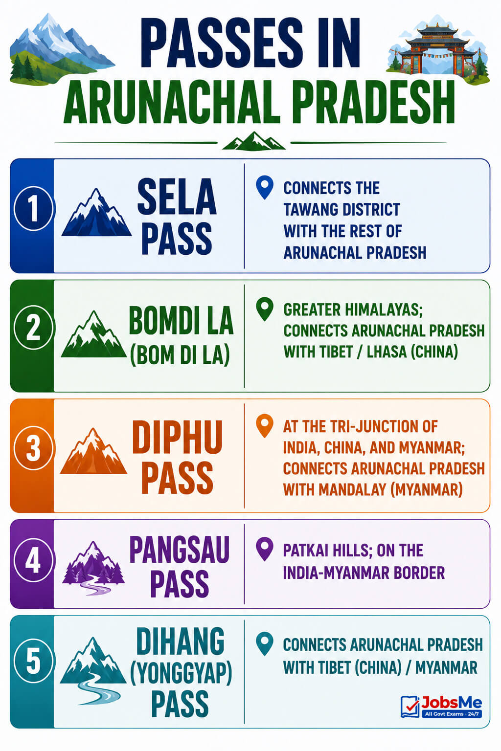
| Pass | Range / Connects | Key Details |
|---|---|---|
| Sela Pass | Connects the Tawang district with the rest of Arunachal Pradesh | Around 4,170 m; a high-altitude pass essential for all-weather connectivity to Tawang; strategically important for India-China border defence. |
| Bomdi La (Bom Di La) | Greater Himalayas; connects Arunachal Pradesh with Tibet/Lhasa (China) | Lies to the east of Bhutan; a key route in the Eastern Himalayas important for India-China border security. |
| Diphu Pass | At the tri-junction of India, China, and Myanmar; connects Arunachal Pradesh with Mandalay (Myanmar) | Around 4,353 m; lies on the McMahon Line; an important all-year land trade route between India and Myanmar. |
| Pangsau Pass | Patkai Hills; on the India-Myanmar border | Around 1,136 m; provides the easiest route into Myanmar from the Assam plains; historically part of the Stilwell Road. |
| Dihang (Yonggyap) Pass | Connects Arunachal Pradesh with Tibet (China) / Myanmar | The Brahmaputra (Tsangpo) enters India through the Dihang gorge near Namcha Barwa after its great U-bend. |
Memory Tricks and Mnemonics
Trick 1: "La" Means Pass — Spot It Instantly
Any Himalayan pass ending in "La" is named in the Tibetan or Ladakhi style, so it almost always lies near a China/Tibet border or a high-altitude trans-Himalayan route.
- La passes: Zoji La, Khardung La, Chang La, Bara-lacha La, Shipki La, Nathu La, Jelep La, Sela, Umling La, Lipulekh.
"If it ends in La, think high and think border."
Trick 2: Highest Motorable — "Umling is Ultimate"
Remember the order of "highest" facts:
- Umling La → world's highest motorable road/pass (opened 2021).
- Khardung La → long famous as one of the highest motorable roads; gateway to Nubra.
"Umling is Ultimate; Khardung is the classic king."
Trick 3: Rivers Through Passes — "Sutlej takes Shipki"
- Sutlej (Satluj) → enters India through Shipki La (both start with "S").
- Chandra and Bhaga (Chenab headwaters) → originate near Bara-lacha La.
- Brahmaputra (Tsangpo) → enters through the Dihang gorge.
"Sutlej takes Shipki, Chenab is born at Bara-lacha."
Trick 4: Tunnels Under Passes — "Atal over Rohtang, Jawahar over Banihal"
- Atal Tunnel → below Rohtang Pass (Himachal Pradesh).
- Jawahar Tunnel → below Banihal Pass (Jammu & Kashmir).
- Zoji La Tunnel → under construction below Zoji La.
Trick 5: India-China Trade Points — "Nathu & Shipki Shake Hands"
The two official India-China border trade passes are easy to pair:
- Nathu La → Sikkim (reopened 2006).
- Shipki La → Himachal Pradesh.
"Two trade gates: Nathu in the east, Shipki in the west."
Trick 6: Tri-junction and Myanmar Passes — "Diphu Touches Three"
- Diphu Pass → tri-junction of India, China, and Myanmar; on the McMahon Line.
- Pangsau Pass → easiest gate from Assam plains into Myanmar.
- Bomdi La & Sela → both guard the road to Tawang in Arunachal Pradesh.
Trick 7: Pilgrim Passes — "Lipulekh, Mana, Niti to Kailash"
Three Uttarakhand passes all lead towards Tibet and the Kailash-Mansarovar route:
- Lipulekh → main pilgrim route to Kailash-Mansarovar.
- Mana Pass → north of Badrinath; among the highest vehicle-accessible passes.
- Niti Pass → another Uttarakhand-Tibet pilgrim approach.
"L-M-N of Uttarakhand all knock on Tibet's door."
Additional Notes
Frequently Confused Facts
- Zoji La vs Banihal: Zoji La connects Srinagar-Kargil-Leh (Gateway to Ladakh); Banihal connects Jammu to the Kashmir Valley (Jawahar Tunnel below it). Both are in J&K but link very different routes.
- Khardung La vs Umling La: Khardung La is the long-famous high motorable road near Leh; Umling La (opened 2021) is now the world's highest motorable road. If the question says "highest in the world today", the answer is Umling La.
- Nathu La vs Jelep La: Both are in Sikkim and connect to Tibet; Jelep La is shaped by the Teesta River and is the easier route, while Nathu La is the official trade point reopened in 2006.
- Shipki La vs Lipulekh: Shipki La is in Himachal Pradesh (Sutlej enters here); Lipulekh is in Uttarakhand (Kailash-Mansarovar pilgrim route). Both touch Tibet.
- Sela vs Bomdi La: Both are in Arunachal Pradesh near Tawang; Sela is the immediate gateway to Tawang town, while Bomdi La lies further along towards Tibet/Lhasa.
- Atal Tunnel vs Jawahar Tunnel: Atal Tunnel is below Rohtang Pass (Himachal); Jawahar Tunnel is below Banihal Pass (J&K). Do not swap them.
- Karakoram vs Aghil Pass: Both lie in the Karakoram Range on the route towards Xinjiang; Karakoram Pass is the historic Silk Route caravan link, while Aghil lies north of the K2 peak.
Repeating PYQ Patterns
Certain passes are asked repeatedly across competitive exams. Zoji La, Khardung La, Nathu La, Shipki La, Rohtang Pass, Banihal Pass, Bara-lacha La, Lipulekh, Mana Pass, Jelep La, and Bomdi La appear most often in UPSC Prelims, SSC CGL, and RRB NTPC papers, usually as state-location pairings, "which river enters India through which pass", or "highest motorable pass" questions. Banking exams (IBPS PO, SBI Clerk) and Insurance exams frequently use simple matching questions linking the pass to its state. Defence exams (NDA, CDS, CAPF) emphasise the strategic and border-security angle — Diphu (tri-junction), Sela and Bomdi La (Tawang sector), and Karakoram (Silk Route). State PCS exams add regional passes — HPPSC asks about Rohtang and Bara-lacha La, JKPSC about Zoji La and Banihal, and APPSC (Arunachal) about Sela, Diphu, and Pangsau.
Quick Insight
Himalayan passes are far more than geographical trivia — they are living strategic assets. Nathu La's reopening for trade reflects India-China diplomacy; the Atal Tunnel below Rohtang and the upcoming Zoji La Tunnel show India's push for all-weather military and civilian connectivity to its frontier regions; and Umling La becoming the world's highest motorable road highlights border infrastructure development. Understanding these passes lets aspirants quickly connect any current affairs headline about border roads, tunnels, or trade routes to its exact location, which is invaluable for both Prelims (direct matching questions) and Mains (geography and internal security answers). For further reading on related Static GK topics, you can explore the Static GK notes and test yourself with the Static GK Quiz on Jobsme.in.
One-Liners for Quick Revision
- Khardung La → Ladakh Range → connects Leh to Nubra and Shyok valleys; gateway to Siachen; long famous as one of the highest motorable roads.
- Umling La → Ladakh → world's highest motorable road/pass; opened August 2021 on the Chisumle-Demchok road.
- Chang La → Ladakh → connects Ladakh with Tibet; on the route to Pangong Lake.
- Karakoram Pass → Karakoram Range → connects Ladakh with Yarkand (Xinjiang); ancient Silk Route.
- Aghil Pass → Karakoram Range → north of K2; connects Ladakh with Xinjiang, China.
- Zoji La → Zaskar Range, J&K → connects Srinagar-Kargil-Leh (NH-1D); Gateway to Ladakh.
- Banihal Pass → Pir Panjal Range, J&K → connects Jammu to Kashmir Valley; Jawahar Tunnel below it.
- Pir Panjal Pass (Peer Ki Gali) → Pir Panjal Range → Mughal Road from Srinagar to Rajouri-Poonch.
- Burzil Pass → connects Astore Valley to Deosai Plains; Astore River originates near it.
- Rohtang Pass → Eastern Pir Panjal, HP → connects Manali (Kullu) to Lahaul-Spiti; Atal Tunnel below it.
- Bara-lacha La → Zaskar Range, HP → connects Lahaul to Leh on Leh-Manali Highway; Chandra and Bhaga rivers originate near it.
- Shipki La → Kinnaur, HP → connects HP with Tibet; Sutlej (Satluj) river enters India here; India-China trade point.
- Debsa Pass → Greater Himalayas, HP → connects Kullu with Spiti.
- Lipulekh Pass → Uttarakhand → connects to Tibet; Kailash-Mansarovar pilgrim route.
- Mana Pass → Greater Himalayas, Uttarakhand → north of Badrinath; among the highest vehicle-accessible passes; connects to Tibet.
- Niti Pass → Uttarakhand → connects to Tibet en route to Kailash-Mansarovar.
- Kalindi Pass → Garhwal Himalayas → glaciated pass near the Indo-Tibet border.
- Nathu La → Sikkim → connects to Tibet; Silk Route point; reopened for trade in 2006.
- Jelep La → Sikkim (Chumbi Valley) → connects to Tibet; shaped by the Teesta River.
- Sela Pass → Arunachal Pradesh → gateway connecting Tawang with the rest of the state.
- Bomdi La → Arunachal Pradesh → connects to Tibet/Lhasa; east of Bhutan.
- Diphu Pass → tri-junction of India, China, Myanmar → connects Arunachal with Mandalay; on the McMahon Line.
- Pangsau Pass → Patkai Hills, Arunachal → easiest route from Assam plains into Myanmar.
- Dihang (Yonggyap) Pass → Arunachal Pradesh → Brahmaputra (Tsangpo) enters India through the Dihang gorge.
For more Static GK topics like Indian rivers, mountain ranges, and national highways, explore the Static GK section on Jobsme.in. You can also test your knowledge with the Static GK Quiz and check the latest exam openings at Latest Government Job Notifications.
Free quiz • No signup required
Put this topic into practice with Indian Cultural Institutions – Static GK MCQ Quiz. It is the quickest way to reinforce what you just learned.
Frequently Asked Questions
Which is the highest motorable pass in the world?
Which river enters India through the Shipki La pass?
Which pass is known as the Gateway to Ladakh?
Which tunnel was built under the Banihal Pass?
Which mountain pass connects Sikkim with Tibet and was reopened for trade in 2006?
Which pass lies at the tri-junction of India, China, and Myanmar?
Which pass serves as the gateway to Tawang in Arunachal Pradesh?
Which passes in Uttarakhand are used for the Kailash-Mansarovar pilgrimage?
Why are so many Himalayan passes named with the word La?
Which Indian region has the highest number of high-altitude mountain passes?

About the author