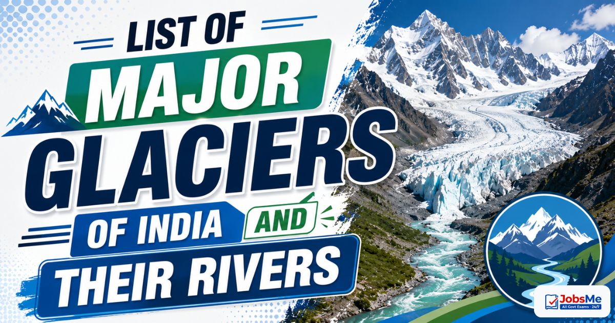
List of Major Glaciers of India and Their Rivers – Static GK & General Awareness for Competitive Exams with Memory Tricks
This article presents a complete list of the major glaciers of India along with their location, mountain range, length, the rivers they feed, and their strategic, religious, and environmental significance. It covers important glaciers like Siachen (largest in India), Gangotri (source of the Ganga), Zemu (largest in the Eastern Himalayas), Yamunotri, Bara Shigri, Pindari, Milam, and Drang-Drung, with memory tricks and one-liners for quick revision. All facts are arranged in exam-ready format to help UPSC, SSC, IBPS, RRB, PSU, and State PCS aspirants score better in General Awareness and Indian Geography sections.
Jump to section
Introduction
India is home to some of the most magnificent glaciers in the world, almost all of them located in the Himalayan and Karakoram mountain ranges across the union territory of Ladakh and the states of Jammu & Kashmir, Himachal Pradesh, Uttarakhand, Sikkim, and Arunachal Pradesh. According to the Space Applications Centre of the Indian Space Research Organisation (ISRO), India has around 16,627 glaciers. The largest among them is the Siachen Glacier, while the Gangotri Glacier is famous as the source of the holy Ganga.
Glaciers are slow-moving masses of ice that act as natural freshwater reservoirs. Their meltwater feeds the great Indian river systems — the Indus, Ganga, Yamuna, and Brahmaputra — sustaining drinking water, irrigation, and hydroelectric power across northern and northeastern India. Questions on Indian glaciers and the rivers they feed appear regularly in UPSC Prelims, SSC CGL, IBPS PO, RRB NTPC, SBI Clerk, State PCS, and various Insurance and Defence exams. To explore other related topics, you can refer to the Static GK section on Jobsme.in.
Glaciers are also closely tied to current affairs themes such as climate change and glacial retreat, Glacial Lake Outburst Floods (GLOFs), the Karakoram Anomaly, the strategic importance of Siachen, and ISRO-Wadia Institute monitoring of the Himalayan cryosphere — making this topic doubly important for aspirants preparing for UPSC Mains and Essay papers as well.
Core Concepts: What Are Glaciers and How Are They Classified
A glacier is a large, persistent body of dense ice that forms where the accumulation of snow exceeds its melting (ablation) over many years, and which moves slowly under its own weight. Glaciers are among the most sensitive indicators of climate change. Understanding the basic concepts helps students answer both factual and conceptual questions confidently.
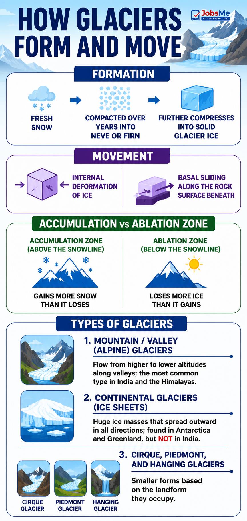
How Glaciers Form and Move
- Formation: Fresh snow is compacted over years into granular ice called Neve or Firn, which further compresses into solid glacier ice.
- Movement: Glaciers move by internal deformation of ice and by basal sliding along the rock surface beneath them.
- Accumulation vs Ablation Zone: The accumulation zone (above the snowline) gains more snow than it loses, while the ablation zone (below the snowline) loses more ice than it gains.
Types of Glaciers
- Mountain / Valley (Alpine) Glaciers: Flow from higher to lower altitudes along valleys; the most common type in India and the Himalayas.
- Continental Glaciers (Ice Sheets): Huge ice masses that spread outward in all directions; found in Antarctica and Greenland, but NOT in India.
- Cirque, Piedmont, and Hanging Glaciers: Smaller forms based on the landform they occupy.
Major Glaciers of India and the Rivers They Feed
The following table lists the most exam-relevant glaciers of India along with their location, mountain range, the rivers they feed, and key features. The Himalayan and Karakoram glaciers are the backbone of India's perennial river systems.
| Glacier | Location / Range | River Fed | Key Features |
|---|---|---|---|
| Siachen Glacier | Eastern Karakoram Range, Ladakh (Nubra Valley) | Nubra (joins Shyok, then Indus) | About 76 km long; the largest and longest glacier in India and the second-longest non-polar glacier in the world. Known as the world's highest battlefield; held by the Indian Army since Operation Meghdoot (1984); lies along the Line of Control with Pakistan; its main tributaries are Lolofond and Teram Shehr. |
| Gangotri Glacier | Uttarkashi district, Uttarakhand (Garhwal Himalayas) | Bhagirathi (source of the Ganga) | About 30 km long; the largest glacier in the Kumaon-Garhwal region and the source of the holy Ganga. Its snout is called Gaumukh ("cow's mouth"); it is a combination of several glaciers, not a single one; retreating at roughly 22 metres per year, monitored by the Wadia Institute and ISRO. |
| Yamunotri Glacier | Uttarkashi district, Uttarakhand (Bandarpunch massif) | Yamuna | Source of the River Yamuna, the largest tributary of the Ganga; lies on the western slopes of the Bandarpunch (Banderpunch) peak; one of the four Char Dham pilgrimage sites. |
| Bandarpunch Glacier | Uttarkashi district, Uttarakhand (Garhwal Himalayas) | Yamuna basin (feeds Tons and Hanuman Ganga) | About 12 km long; "Bandarpunch" means "monkey's tail," linked to the legend of Lord Hanuman; formed by cirque glaciers; the Tons River, the largest tributary of the Yamuna, rises from this region. |
| Zemu Glacier | North Sikkim (Eastern Himalayas) | Teesta (part of Brahmaputra system) | About 26 km long; the largest glacier in the Eastern Himalayas; lies at the base of Kangchenjunga, the world's third-highest peak; vital water source for Sikkim and West Bengal. |
| Bara Shigri Glacier | Chandra Valley, Lahaul & Spiti, Himachal Pradesh | Chandra (forms Chenab after meeting Bhaga) | The longest glacier in Himachal Pradesh; "Bara Shigri" means "big glacier" in the Lahaul dialect; feeds the Chandra River, which becomes Chandrabhaga (Chenab) at Tandi; known for antimony deposits. |
| Drang-Drung Glacier | Kargil district, Ladakh (Zanskar Range) | Stod (tributary of Zanskar, then Indus) | Also known as the Drung Glacier; about 23 km long at an average elevation of around 4,780 m; one of the largest glaciers in the Zanskar region; located south of Kargil and east of Srinagar. |
| Milam Glacier | Pithoragarh district, Uttarakhand (Kumaon Himalayas) | Gori Ganga (tributary of the Kali/Sharda) | The largest glacier in the Kumaon region; located about 15 km northeast of Nanda Devi; lies between the Trishul and Hardeol peaks; a popular trekking destination reached from Munsiyari. |
| Pindari Glacier | Bageshwar district, Uttarakhand (Kumaon Himalayas) | Pindar (tributary of the Alaknanda) | Lies between the Nanda Devi and Nanda Kot peaks; the Pindar River joins the Alaknanda at Karnaprayag (one of the Panch Prayag); a famous and accessible trek ending at "Zero Point." |
| Dokriani Glacier | Uttarkashi district, Uttarakhand (Garhwal Himalayas) | Din Gad (feeds the Bhagirathi) | An extensively studied benchmark glacier monitored by the Wadia Institute and Geological Survey of India; has retreated significantly over recent decades, important in climate change research. |
| Chorabari Glacier | Rudraprayag district, Uttarakhand (near Kedarnath) | Mandakini (tributary of the Alaknanda) | Source of the Mandakini River; the bursting of the Chorabari (Gandhi Sarovar) glacial lake during the June 2013 Kedarnath disaster caused a devastating flood. |
| Satopanth & Bhagirathi Kharak Glaciers | Chamoli district, Uttarakhand (Garhwal Himalayas) | Alaknanda | Located near the headwaters of the Alaknanda; the Bhagirathi Kharak and Satopanth glaciers together feed the Alaknanda, which later meets the Bhagirathi at Devprayag to form the Ganga. |
| Kolahoi Glacier | Anantnag district, Jammu & Kashmir (Lidder Valley) | Lidder (feeds the Jhelum) | The main source of the Jhelum River system in Kashmir; located near Pahalgam; shrinking rapidly, having lost a large part of its area over the last century. |
| Sonapani Glacier | Chandra Valley, Lahaul & Spiti, Himachal Pradesh (Pir Panjal) | Chandra basin | One of the notable glaciers of the Pir Panjal Range; the glaciers of the Pir Panjal are fewer and smaller than those of the Karakoram. |
| Kangto / Bichom Glaciers | Arunachal Pradesh (Eastern / Great Himalayas) | Brahmaputra tributaries | Located along the Tibetan border where peaks rise above 4,500 m and stay snow-covered year-round; among the few glaciers found in the Eastern-most Himalayan state of India. |
World Context: Where Indian Glaciers Stand
For comparison-based questions, it helps to remember how Indian glaciers rank globally and against other non-polar glaciers.
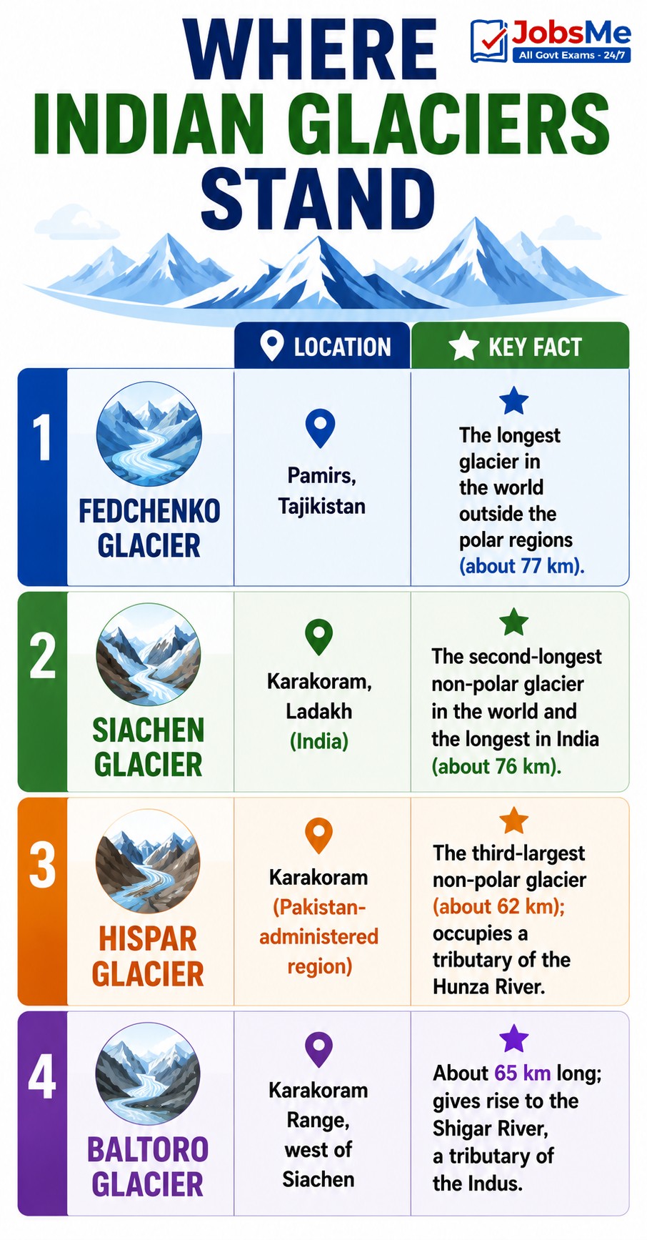
| Glacier | Location | Key Fact |
|---|---|---|
| Fedchenko Glacier | Pamirs, Tajikistan | The longest glacier in the world outside the polar regions (about 77 km). |
| Siachen Glacier | Karakoram, Ladakh (India) | The second-longest non-polar glacier in the world and the longest in India (about 76 km). |
| Hispar Glacier | Karakoram (Pakistan-administered region) | The third-largest non-polar glacier (about 62 km); occupies a tributary of the Hunza River. |
| Baltoro Glacier | Karakoram Range, west of Siachen | About 65 km long; gives rise to the Shigar River, a tributary of the Indus. |
Glacial Landforms and Geomorphology
Glaciers carve distinctive landforms that are frequently asked in the geography sections of competitive exams. The following are the most important erosional landforms created by moving ice.
- Cirque (Corrie): A bowl-shaped hollow at the head of a glacial valley; when filled with water it forms a tarn (for example, Roopkund Lake).
- Arete: A sharp, knife-edged ridge formed between two cirques.
- Horn / Pyramidal Peak: A sharp peak formed when three or more cirques erode a mountain from different sides (Shivling near Gangotri is called "India's Matterhorn").
- U-shaped Valley (Glacial Trough): A wide, deep valley carved by a glacier; the Kashmir Valley is a classic example.
- Hanging Valley: A smaller tributary valley left high above the main valley, often forming waterfalls.
- Moraine: Debris of rock and soil deposited by a glacier; terminal moraines often dam glacial lakes.
- Roche Moutonnee: A rock mound with a smooth, polished up-slope side and a steep, plucked down-slope side.
Memory Tricks and Mnemonics
Trick 1: Largest Glaciers — "Siachen is Supreme"
To remember the size ranking of India's glaciers:
- Siachen → largest glacier in India (Karakoram, Ladakh).
- Gangotri → largest in the Kumaon-Garhwal / Central Himalayas (source of the Ganga).
- Zemu → largest in the Eastern Himalayas (Sikkim).
- Bara Shigri → longest in Himachal Pradesh.
- Milam → largest in the Kumaon region.
"Siachen for India, Zemu for the East, Bara Shigri for Himachal."
Trick 2: Glacier-to-River Pairs — "Great Glaciers Yield Big Streams"
Match each glacier to the river it feeds, a very common exam question:
- G → Gangotri → Ganga (Bhagirathi).
- Y → Yamunotri → Yamuna.
- S → Siachen → Nubra (Indus system).
- Z → Zemu → Teesta.
- B → Bara Shigri → Chandra/Chenab.
"GYS-ZB — five glaciers, five lifelines of India."
Trick 3: "Express" and "Tiger" Glaciers vs Sacred Ones
Contrast the strategic glaciers with the religious ones:
- Strategic / Defence: Siachen (world's highest battlefield), Drang-Drung (Kargil region).
- Sacred / Char Dham: Gangotri (Ganga), Yamunotri (Yamuna), Chorabari (near Kedarnath), Satopanth (Pandava legend).
Trick 4: The Karakoram Quartet — "S-B-D in the Karakoram/Zanskar"
The northern (Ladakh) glaciers lie in the Karakoram and Zanskar ranges:
- S → Siachen (Eastern Karakoram).
- B → Baltoro (Karakoram, west of Siachen).
- D → Drang-Drung (Zanskar Range, Kargil).
"All three drain into the mighty Indus system."
Trick 5: Snout Names — "Gaumukh = Cow's Mouth"
Remember that the snout (terminus) of the Gangotri Glacier is called Gaumukh, meaning "cow's mouth," from where the Bhagirathi (Ganga) emerges. Pilgrims trek about 18 km from Gangotri town to reach it.
Trick 6: Disaster Glaciers — "Chorabari Caused Kedarnath"
Two glacier-linked disasters are commonly tested:
- Chorabari Glacier → the 2013 Kedarnath GLOF and flood.
- South Lhonak Lake (Sikkim) → the October 2023 GLOF that destroyed the Chungthang dam.
Trick 7: Eastern Edge — "Kangto in Arunachal, Zemu in Sikkim"
For the Eastern Himalayas, link the state to its glacier:
- Sikkim → Zemu Glacier (near Kangchenjunga, feeds Teesta).
- Arunachal Pradesh → Kangto and Bichom glaciers along the Tibetan border.
Additional Notes
Frequently Confused Facts
- Largest glacier in India vs source of the Ganga: Siachen is the largest glacier in India; Gangotri is the source of the Ganga (often wrongly assumed to be the same glacier).
- Gangotri snout vs glacier: Gaumukh is the snout (terminus) of the Gangotri Glacier, not a separate glacier.
- Yamuna source: The Yamuna rises from the Yamunotri Glacier on the western slopes of the Bandarpunch massif — Yamunotri and Bandarpunch are closely linked but not identical.
- Milam vs Mandakini: The Milam Glacier is the source of the Gori Ganga (a tributary of the Kali), NOT the Mandakini. The Mandakini originates from the Chorabari Glacier near Kedarnath.
- Zemu vs Manas: The Zemu Glacier feeds the Teesta River, NOT the Manas (the Manas rises from glaciers in Bhutan).
- Bara Shigri river: Bara Shigri feeds the Chandra River, which becomes the Chenab after joining the Bhaga at Tandi.
- Largest in the East vs largest in India: Zemu is the largest in the Eastern Himalayas; Siachen is the largest in all of India.
- Fedchenko vs Siachen: Fedchenko (Pamirs, Tajikistan) is the longest non-polar glacier in the world; Siachen is second and the longest in India.
- Ice sheets in India: India has only valley (mountain) glaciers; continental ice sheets are found in Antarctica and Greenland, never in India.
Repeating PYQ Patterns
Certain glacier facts are asked repeatedly in competitive exams. Siachen (largest glacier in India, world's highest battlefield, feeds Nubra), Gangotri (source of the Ganga, snout Gaumukh), Zemu (largest in Eastern Himalayas, feeds Teesta), Yamunotri (source of Yamuna), Bara Shigri (longest in Himachal, feeds Chenab), and Milam (largest in Kumaon, feeds Gori Ganga) appear most often in UPSC Prelims, SSC CGL, and RRB NTPC papers. UPSC has repeatedly set "match the glacier with the river" questions (Bandarpunch-Yamuna, Bara Shigri-Chenab, Milam-Gori Ganga, Siachen-Nubra, Zemu-Teesta). Banking exams (IBPS PO, SBI Clerk) usually ask straightforward "which is the largest/longest glacier in India" type questions, while State PCS exams add regional details — Uttarakhand PCS focuses on Gangotri, Pindari, Milam, and Chorabari, Himachal PCS on Bara Shigri and Sonapani, and J&K/Ladakh exams on Siachen, Drang-Drung, and Kolahoi.
Quick Insight
Glaciers are far more than frozen landscapes — they are the water towers of India and sensitive barometers of climate change. The Gangotri Glacier has retreated by more than 2 km since 1780 and continues to recede at roughly 22 metres a year, while the Karakoram glaciers such as Siachen have remained relatively stable, a phenomenon scientists call the "Karakoram Anomaly." Accelerating retreat is forming new glacial lakes and raising the risk of Glacial Lake Outburst Floods (GLOFs), as seen in the 2013 Kedarnath disaster and the 2023 South Lhonak Lake flood in Sikkim. The Wadia Institute of Himalayan Geology (Dehradun) and ISRO continuously monitor these glaciers. For further reading on related topics, you can refer to the Static GK notes and stay updated through the Daily Current Affairs section on Jobsme.in.
One-Liners for Quick Revision
- Siachen Glacier → Largest and longest glacier in India (about 76 km) → Eastern Karakoram, Ladakh; feeds the Nubra; world's highest battlefield.
- Gangotri Glacier → Source of the Ganga (Bhagirathi) → Uttarkashi, Uttarakhand; snout is Gaumukh; about 30 km long.
- Yamunotri Glacier → Source of the Yamuna → Bandarpunch massif, Uttarakhand; a Char Dham pilgrimage site.
- Bandarpunch Glacier → Feeds the Yamuna basin (Tons, Hanuman Ganga) → Uttarkashi; means "monkey's tail."
- Zemu Glacier → Source of the Teesta → North Sikkim; largest glacier in the Eastern Himalayas; near Kangchenjunga.
- Bara Shigri Glacier → Feeds the Chandra/Chenab → Lahaul & Spiti, Himachal Pradesh; longest glacier in the state.
- Drang-Drung Glacier → Feeds the Stod (Zanskar/Indus) → Kargil, Ladakh; in the Zanskar Range; also called Drung Glacier.
- Milam Glacier → Source of the Gori Ganga → Pithoragarh, Uttarakhand; largest glacier in the Kumaon region.
- Pindari Glacier → Source of the Pindar (Alaknanda) → Bageshwar, Uttarakhand; popular trek ending at Zero Point.
- Dokriani Glacier → Feeds the Bhagirathi (via Din Gad) → Uttarkashi; a key benchmark glacier for climate studies.
- Chorabari Glacier → Source of the Mandakini → near Kedarnath; linked to the 2013 Kedarnath disaster.
- Satopanth & Bhagirathi Kharak Glaciers → Feed the Alaknanda → Chamoli, Uttarakhand; near its headwaters.
- Kolahoi Glacier → Source of the Lidder (Jhelum) → Anantnag, J&K; near Pahalgam; shrinking rapidly.
- Sonapani Glacier → Chandra basin → Pir Panjal Range, Himachal Pradesh.
- Kangto / Bichom Glaciers → Brahmaputra tributaries → Arunachal Pradesh, along the Tibetan border.
- Fedchenko Glacier → Longest non-polar glacier in the world → Pamirs, Tajikistan (about 77 km).
- Baltoro Glacier → Source of the Shigar (Indus) → Karakoram, west of Siachen.
- Gaumukh → Snout of the Gangotri Glacier → "cow's mouth"; emergence point of the Bhagirathi.
- Karakoram Anomaly → Karakoram glaciers stable/advancing while most Himalayan glaciers retreat.
- Wadia Institute of Himalayan Geology → India's premier glacier research centre, Dehradun.
For more Static GK topics like Indian rivers, mountain passes, and national parks, explore the Static GK section on Jobsme.in. You can also test your knowledge with the Static GK Quiz and check out the latest exam notifications at Latest Government Job Notifications.
Free quiz • No signup required
Put this topic into practice with Indian Cultural Institutions – Static GK MCQ Quiz. It is the quickest way to reinforce what you just learned.
Frequently Asked Questions
Which is the largest glacier in India?
Which glacier is the source of the river Ganga?
What is Gaumukh and why is it important?
Why is the Siachen Glacier strategically important?
Which is the largest glacier in the Eastern Himalayas?
Which river originates from the Yamunotri Glacier?
Which glacier feeds the Chenab River?
How many glaciers does India have?
What is a Glacial Lake Outburst Flood (GLOF)?
Why are Himalayan glaciers important for India's rivers?

About the author